Here’s how NASA-ISRO joint satellite NISAR predicts India's agricultural future
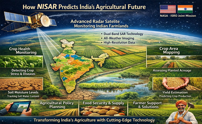
India has launched a special satellite called NISAR—the NASA-ISRO Synthetic Aperture Radar. It was sent to space on July 30, 2025, and it is designed to help Indian farmers in a completely new way. Think of NISAR as a doctor for our land. Just like a doctor examines your body to know what is happening inside, this satellite examines our soil to understand how much water is present and how our land is changing. Every twelve days, it scans India's farmland and sends back detailed information that can help us grow better crops and save water.
NISAR works by using two different types of radar signals that work together. NASA provides something called L-band radar, which is like X-ray vision for the ground. This signal can pass through thick forests, plants, and soil layers to see what is happening deep below the surface. ISRO provides S-band radar, which is like a regular camera that gives clear details of what is on top. When both signals work together, they create a complete picture of our land. The satellite's large 12-metre antenna reflector, which looks like a huge wire mesh, opened up in space after launch. This antenna sends and receives radar signals, allowing the satellite to capture extremely clear images. The satellite orbits Earth in a special path called a 747 km Sun-synchronous polar orbit, which means it passes over the same spots on Earth at the same time each day.
The special feature that makes NISAR so powerful is something called 100-metre resolution mapping. This is an important concept to understand. Imagine dividing your entire neighbourhood into small square blocks, where each block is 100 metres long and 100 metres wide. The satellite measures the soil moisture in each of these blocks separately. Soil moisture simply means how much water is present in the soil. This information is incredibly useful because farmers can know exactly where their fields have enough water, where they need to add water, and where water might be wasted.
NISAR can scan a very wide area of about 240 kilometres in one single pass. This is possible because of something called SweepSAR technology. Because it covers such a huge area, the satellite can scan the entire Earth every twelve days. It sends new information twice within these twelve days, making it almost like having constant monitoring of our land's health.
The information collected by NISAR is being sent to the Space Applications Centre, where advanced computers analyse the data. The NISAR satellite-based maps and data products are currently being tested using ground sensors across different soil types to make sure they are accurate. These tests compare what the satellite says with actual measurements taken on the ground. After verification, this information is shared with people through something called the Bhoonidhi Portal, which is an online platform created by ISRO. Anyone can access this real data anytime they want. A farmer can check it at 2 PM or even at midnight. A government official can plan irrigation schedules using this actual information. A researcher can study water availability patterns across different regions.
NISAR is particularly important for India because our monsoons are becoming unpredictable. Sometimes we get too much rain, sometimes too little. Farmers currently make decisions based on experience and guesses, but NISAR gives them actual data. The satellite can help identify which areas might face drought before it actually happens. This warning system allows farmers and government officials to take action early.
Most soil maps available in the world are not very clear and detailed. NISAR's 100-metre view is much sharper than anything we had before. It can spot small changes in soil and water conditions even within a single district. This detailed information helps in planning irrigation better, saving water, and growing more food. By understanding water availability accurately, India can now manage its water resources wisely and prepare for climate change effects. NISAR represents the power of international cooperation, with America and India working together to protect India's agricultural future and food security.
(Girish Linganna is an award-winning science communicator and a Defence, Aerospace & Geopolitical Analyst. He is the Managing Director of ADD Engineering Components India Pvt. Ltd., a subsidiary of ADD Engineering GmbH, Germany)
Disclaimer: The views and opinions expressed in this article are solely those of the author. They do not necessarily reflect the views, policies, or position of the publication, its editors, or its management. The publication is not responsible for the accuracy of any information, statements, or opinions presented in this piece.
Let the Truth be known. If you read VB and like VB, please be a VB Supporter and Help us deliver the Truth to one and all.
Two killed as college tour bus crashes into parked tanker, lorry near Maravanthe

Kundapur: Two persons died and several students were injured after a college tour bus rammed into a tanker and a goods lorry parked by the roadside near Maravanthe Beach in Trasi on Wednesday afternoon.
The bus was carrying final-year B.Com students of Rambhapuri College from Shivamogga district. According to sources, the group had left for the tour two days ago.
There were around 50 persons in the bus, including 24 male students and 23 female students.
The students had visited Murdeshwar and were travelling towards Udupi on Wednesday when the accident occurred.
Police said the bus driver reportedly lost control of the vehicle, following which the bus first hit a parked gas tanker and then crashed into a goods lorry stationed ahead.
The front portion of the bus was badly mangled in the impact. Preliminary information said the bus cleaner and a cooking assistant travelling with the group died in the accident. Several injured students were shifted to different hospitals in Kundapur for treatment.