Man hands over urn containing soil from houses of soldiers killed in Pulwama terror attack to CRPF
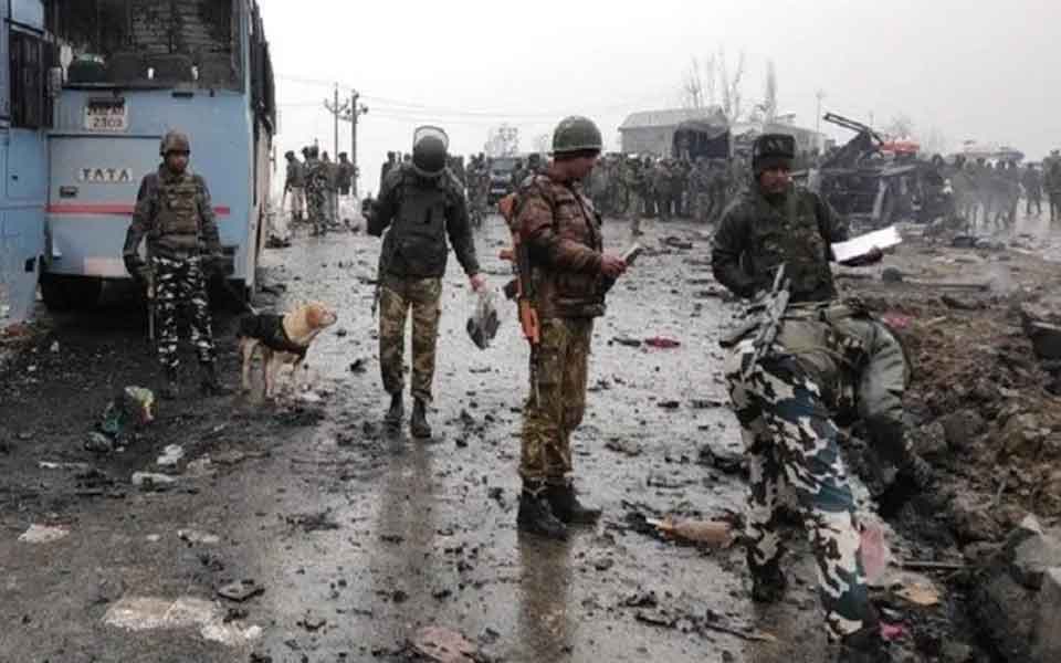
Srinagar: A man from Maharashtra handed over an urn containing soil collected from the homes of each soldier killed in the Pulwama terror attack last year to the CRPF on Friday.
The urn was placed at the Martyrs Column during the wreath-laying ceremony at the Central Reserve Police Force (CRPF) campus in the Lethpora camp here to mark a year of the Pulwama attack, in which 40 personnel of the paramilitary force were killed.
Umesh Gopinath undertook a 61,000-km journey to meet the families of the 40 slain CRPF personnel and collected the soil from their homes.
On February 14 last year, a convoy of vehicles carrying security personnel on the Jammu-Srinagar National Highway was attacked by a vehicle-borne suicide bomber at Lethpora in Jammu and Kashmir's Pulwama district. Forty CRPF personnel were killed in the attack.
"Umesh Gopinath from Maharashtra took a 61,000 Km journey to meet the families of the 40 @crpfindia Martyrs & collected soil from the homes of each Martyr in an Urn. He presented the Urn to CRPF, which was then placed at the Martyrs Column during the wreath laying ceremony," the paramilitary force said in a tweet.
A memorial to the 40 slain personnel has been set up inside a CRPF camp adjacent to the place where Jaish-e-Mohammed (JeM) terrorist Adeel Ahmed Dar, driving an explosive-laden car, blew himself up next to a convoy of security forces.
Almost all the conspirators behind the dastardly attack have since been killed with the last one being Qari Yasir, the self-styled chief of JeM, who was killed last month.
Let the Truth be known. If you read VB and like VB, please be a VB Supporter and Help us deliver the Truth to one and all.
How Indian AI Is Booming with GEOX AI Leading the Next Wave of Geolocation Intelligence
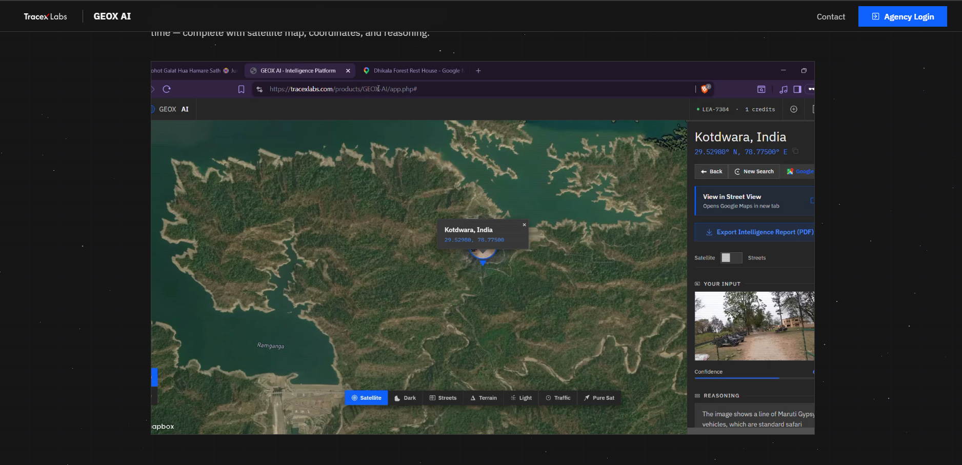
TraceX Labs has announced the launch of GEOX AI, an advanced artificial intelligence platform capable of identifying the real-world location where a photograph or video was taken using only the visual content within the media.
Positioned as an enterprise-grade intelligence solution, GEOX AI leverages advanced computer vision and multi-agent AI to analyze pixel-level details such as architecture, road patterns, vegetation, signage, lighting, and environmental context. By interpreting these visual clues, the system can estimate—and in many cases precisely determine—the origin of an image or video.
AI-Powered Geolocation Intelligence
Marketed under the concept of “Locate Anywhere From Any Image,” GEOX AI is designed for intelligence operations where speed, accuracy, and reliability are critical. The platform currently supports:
- 400+ analyses available
- <10 seconds average response time
- Up to 99% accuracy on landmark-based identification
- Global coverage across diverse terrains and environments
Core Capabilities
GEOX AI integrates multiple intelligence features into a single platform:
- Precise Geolocation:
Identifies exact geographic coordinates using visual landmarks, architecture, vegetation, and cultural indicators. - Satellite Map View:
Results are plotted on live satellite imagery with 2D/3D viewing options and multiple map styles for deeper analysis. - AI Reasoning Analysis:
Provides a detailed explanation of how the system arrived at a conclusion, including confidence scoring. - Multi-Result Analysis:
Returns multiple possible locations ranked by confidence, enabling cross-verification. - Intelligence PDF Export:
Allows one-click generation of professional reports containing maps, coordinates, analysis, and structured findings. - Credit-Based Access:
Agencies are allocated credits, with each analysis consuming one credit. Additional credits can be requested directly.
Speed Meets Intelligence
GEOX AI is designed to balance rapid processing with analytical depth:
- Fast Mode: Delivers results within seconds for clear and high-context images
- Advanced Mode: Performs deeper multi-step analysis for complex or ambiguous visuals
- Built for real-time decision-making in high-pressure environments
How GEOX AI Works
The platform follows a simple and efficient workflow:
- Upload any image or video frame
- AI analyzes visual clues such as structures, terrain, and environment
- The system identifies location with coordinates, confidence score, and reasoning
- Results are displayed on an interactive satellite map
- Export a professional intelligence report in one click
A Breakthrough for Investigations
GEOX AI is expected to have wide-ranging applications across multiple domains:
- Tracking the origin of images from social media and open sources
- Supporting digital forensics and cyber investigations
- Assisting law enforcement and intelligence operations
- Helping journalists and OSINT analysts verify visual content
- Providing support in missing person cases and threat intelligence scenarios
Enterprise Access and Deployment
GEOX AI is available to verified law enforcement agencies, intelligence organizations, and authorized enterprises. Access is provided through a structured system where organizations can request credentials and define their operational use cases.
Interested users can request access via tracexlabs.com or contact contact@tracexlabs.com, with response times typically within 24–48 hours.
Privacy Debate Intensifies
The launch of GEOX AI has also sparked renewed discussion around digital privacy. By demonstrating how location data can be extracted purely from visible elements within images, the platform highlights the potential risks associated with sharing photos online without considering what those visuals may reveal.
Conclusion
With GEOX AI, TraceX Labs is entering the rapidly evolving geolocation intelligence space with a platform that combines speed, precision, and real-world usability. As artificial intelligence continues to advance, tools like GEOX AI are expected to play a critical role in shaping the future of investigations, security, and digital intelligence.