Engineers work on repairing 19th crest gate of Pampa Sagar dam
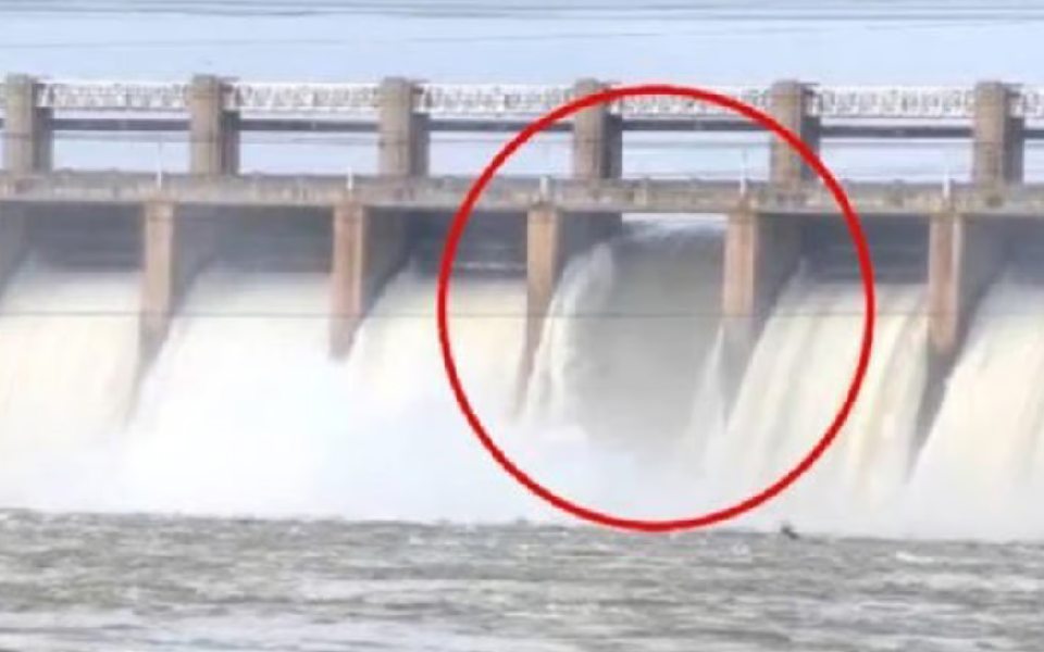
Koppal, Karnataka: Engineers have been sweating it out to fix a new crest gate of the Pampa Sagar dam on Tungabhadra river in Koppal after the existing one was swept away on August 11.
The replacement of the crest gate started from Wednesday night and is likely to take at least another 24 hours to 48 hours, sources in the Water Resources department said.
The Karnataka government has roped in hydro-mechanical engineer N Kannaiah Naidu from Hyderabad to fix the 19th gate of the dam, the sources added.
Speaking to reporters on Thursday, Naidu said usually the life span of the crest gate of a dam is about 40 years but the one which swept away, had served 30 more years than the average.
ALSO READ: CM Siddaramaiah issues direction to restore damaged crest gate of Tungabhadra reservoir in 3-4 days
After the gate gave way late on Sunday night, all the gates of the dams were opened and water was released to prevent any damage to the dam.
The exercise included reducing the existing water holding capacity 105 TMC to 65 TMC to minimise the stress on the dam and carry out repair work at the earliest.
An alert has been sounded to the districts downstream of Tungabhadra river in Karnataka, Telangana and Andhra Pradesh.
Let the Truth be known. If you read VB and like VB, please be a VB Supporter and Help us deliver the Truth to one and all.
Heavy rain, hailstorms lash parts of Uttarakhand; all districts put on high alert
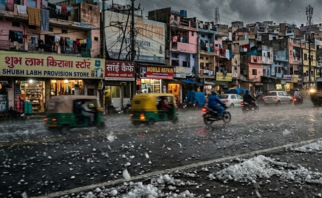
Dehradun (PTI): Heavy rain and hailstorms accompanied by strong winds lashed several districts of Uttarakhand on Sunday morning, prompting the state administration to put all district authorities on high alert.
The sudden change in weather caused uprooted trees to block roads and disrupted power supply at various locations.
Disaster Management and Rehabilitation Secretary Vinod Kumar Suman chaired a review meeting with district officials to assess the situation.
The India Meteorological Department (IMD) has forecast light to moderate rain and thunderstorms at most places across all districts for Monday and Tuesday. Snowfall is expected in regions situated at altitudes of 4,000 metres and above.
An 'orange alert' remains in place for Dehradun, Haridwar, Tehri, Pauri, Nainital, Champawat, and Udham Singh Nagar. These districts are likely to witness isolated heavy rain, hailstorms, and intense to very intense spells of rain accompanied by gusty winds reaching speeds of 40-50 kmph, the IMD said.
The weather office predicted that maximum temperatures across the state are likely to fall by 3-5 degrees Celsius over the next three to four days. During the past 24 hours, maximum temperatures remained "markedly below normal" in the plains and ranged from "markedly" to "appreciably" below normal in the hilly regions.
Dehradun experienced dark, overcast skies early Sunday, creating night-like conditions during morning hours. The city recorded a maximum temperature of 34.7 degrees Celsius, 5.3 degrees Celsius below the seasonal average.
For the state capital, the forecast predicts a partly to generally cloudy sky with a high of 31 degrees Celsius and a low of 19 degrees Celsius.
Significant rainfall was recorded across the state after 8.30 am on Sunday, with Jollygrant receiving 21.6 mm and Mohakampur recording 19.8 mm. Other areas, including Mukteshwar (15.0 mm), Mussoorie (13.4 mm), and Pithoragarh (8.5 mm), also saw measurable precipitation.
Secretary Suman directed officials to clear blocked roads on priority to ensure public convenience. Specific instructions were issued regarding the Char Dham Yatra, ordering that helicopter services must operate strictly according to weather conditions to ensure pilgrims' safety.
Isolated places in the remaining hilly districts are also expected to experience thunderstorms with lightning and intense rain spells.